Seven of the Most Amazing Hiking Destinations in Italy
Choosing a hiking destination in Italy can be like choosing a ‘coffee’ bar in Amsterdam, a castle to visit in Scotland or a sauna in Sweden – with so many options, it can all get a little bit overwhelming and you’re likely not to be disappointed with your choice! Luckily, we’re here with the following guide to our top seven spots and trails in this incomparably scenic heaven for hikers – Bella Italia!
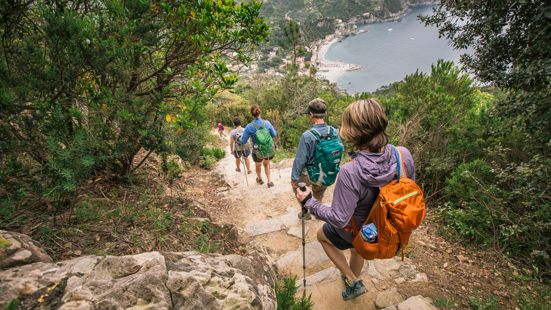
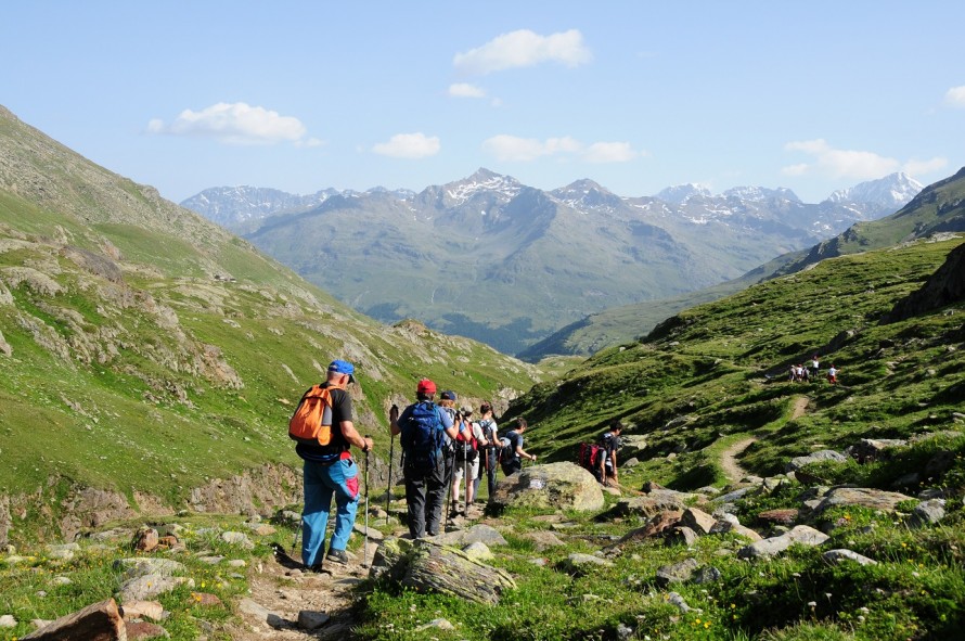
1. Cinque Terre
A bit of a wild card entry in our list, Italy’s world-famous tourist destination Cinque Terre is nevertheless very worthy of its place. Better known as a haunt for sightseers or seaside loungers, this jewel in Italy’s upper northwest flank is also a haven for more moderate but nevertheless spectacular coastal hiking. Between Levanto and Portovenere at either end of the Cinque Terre National Park, there are dozens upon dozens of trails skirting the seaside cliffs, beaches, and passing though some of the most picturesque villages on our planet. Although the trails can get a bit busy in the summer months, it’s well worth putting up with the traffic just to experience the magic of this often overlooked trekkers’ paradise.
Pros
- Gorgeous coastal scenery
- Lots of trail options
- Great food!
- Incredibly picturesque villages and towns en route
- Trekking can be alternated with beach days
- Easy trekking
- Very busy in summer and Easter holiday periods
- Accommodation can be pricey
- Not the most challenging for serious hikers
Congestion: High in summer months and during Easter holidays.
Ideal Time of Year to Hike: All year round.
Total Distance and Duration: Varies from trail to trail. The best of the many routes are the High Path/Alta Via (23miles, 2-4 days, 700m/2296ft total elevation gain) and the Blue Path (6.5 miles, 1 day, 100m/328ft total elevation gain). In each area there are a multitude of short day-treks which can be combined to span well over 50 miles.
Trail Uses: Walking /hiking. Most trails have sections with stairs and so are unsuitable for bikes.
Dogs Allowed: Yes.
Recommended Gear: Trekking shoes (boots not necessary) and water, lots of water!
Elevation at Trailhead: Sea level!
Costs: Varies from around $50 for budget options in low season to $200 per night for 3-Star options in summer.
Directions: From Genoa, follow the E80 south-east and signs for Levanto or Cinque Terre. In Levanto the trails begin just south of town. Parking is limited, so finding a parking lot in town and walking to the trailhead is your best option.
2. Alta Via #1, the Italian Dolomites
Pros
- Stages end at friendly mountain huts where you can eat and sleep for around $45-65 per night
- Absolutely breathtaking scenery
- Suitable for hikers of all abilities and ages
- Very well-maintained and waymarked trail
- Walk through a UNESCO World Heritage Site
- Views of Civetta, Tofane and Pelmo mountains.
- WWI museum at Rifugio Lagazuoi
Cons
- It can get brutally hot in July and August
- They don’t make SD cards big enough for all the photos you’re going to take, so be sure to bring a spare!
- Virtually impossible in winter months due to snow and ice conditions
Congestion: Fairly heavy in the July and August, but not prohibitively so or enough to spoil your hike.
Ideal Time of Year to Hike: Mid-June to mid-September.
Total Distance and Duration: 75-95 miles, 8-12 days (each stage is 4-8 hours walking per day, with multiple add-ons and diversions to extend your trip)
Trail Uses: Hiking, running, via ferrata (optional).
Dogs Allowed? Yes. If taking a dog, use the diversion which avoids the via ferrata on the Schiara at the end of the route (unless your dog happens to be something of an expert alpinist!).
Recommended Gear: Day pack, hiking boots, 50spf sunscreen, hat, sleeping bag liner for huts ,water purification tablets, ice axe (Piolet style) for early in the season, via ferrata kit (optional).
Elevation at Trailhead: Dobbiaco (German: Toblach), 1241m/4,072ft
Max Elevation: 2752m/9,029ft
Total Height Gain: 6,665m /21,833ft
Costs: Around $45-65 per night (bed and breakfast) in a ‘rifugio’ (mountain hut).
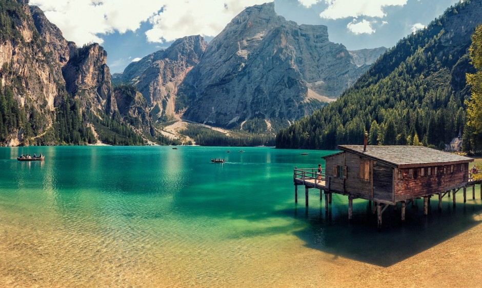
Directions: To drive directly to the trailhead at Lago di Braies (most overnight in Dobbiacco and then catch a bus or drive to Braies, though this section can also be done on foot in 4/5 hours) from the Puster Valley (Val Pusteria), after about 43km (27 miles), between Welsberg and Niederdorf, turn south on the road for Prags. Follow the road for 8km (5 miles) to the carpark.
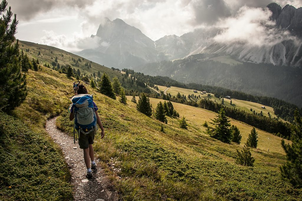
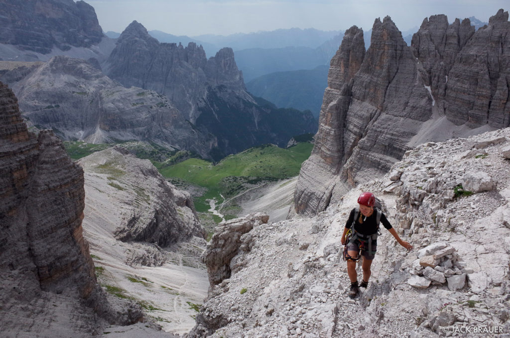
3. Alta Via #2, the Italian Dolomites
Courtesy of Ken Driese
Deciding which is the most beautiful of the Dolomites’ high trails is something you could spend a lifetime debating. In an ideal world, and with plenty free time on your hands, you could simply do all of them, on repeat, until you’ve reached a decision! Because the Dolomites region is so vast, we’ve decided to highlight only the best of the best and AV2 is a dead-heat contender for the top trail that this outrageously pretty part of the world has to offer.
Alta Via #2 takes in equally sublime scenery as AV1, but runs a little longer and threads a more varied and challenging route through the western end of the Dolomites range. The landscapes are overwhelmingly sumptuous, taking in views of the mighty Marmolada (the Dolimites’ highest peak), and passing through the Pale di San Martino Group, the Sella Group and then wilder stretches as your near Feltre. Dubbed the ‘High Route of the Legends’, Alta Via #2 is more strenuous than #1 and keeps you higher for longer but rewards the effort with beautiful scenery and an ever-changing array of mountain landscapes.
Pros
- Has it all – high passes, alpine meadows, picturesque villages, via ferrata routes (optional) and mountaintop moonscapes
- Passes through the exquisite Val Gardena
- Option to climb Marmolada, the highest peak in the Dolomites
- Contained within the Dolomites UNESCO World Heritage Site
Cons
- More challenging than Alta Via #1 (a ‘pro’ for some!)
- As above, the heat can be excessive for some hikers from more moderate climates
- Too challenging for most in winter months
Congestion: Only really bad in the last week of July and early August
Ideal Time of Year to Hike: Early July or Early September
Total Distance and Duration: 77-114miles, 8-14 days (there are several optional stages to this route)
Trail Uses: Hiking, running, via ferrata.
Dogs Allowed: Yes. Again, avoid the via ferrata sections!
Recommended Gear: Large-ish day pack, hiking boots, sleeping bag liner for huts, 50spf sunscreen, hat, water purification tablets, ice axe (Piolet style) for early in the season, via ferrata kit (optional).
Elevation at Trailhead: Bressanone (Brixen), 559m/1,834ft.
Max Elevation: 2,900m / 9,514ft.
Total Height Gain: 11,600m/38,000ft (yeah, that’s more than climbing Everest!)
Costs: Around $50-60 per night in huts, otherwise none.
Directions: From Bressanone railway station, take Via Mozartalee due east and follow signs for Plose. At Plose, you can either choose to hike the 1100m/3608ft elevation gain (around 2 ½ hours) to Valcroce or take the gondola (about 15 mins)!
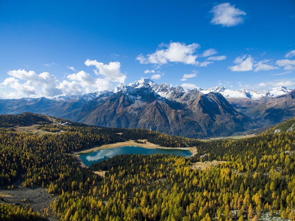
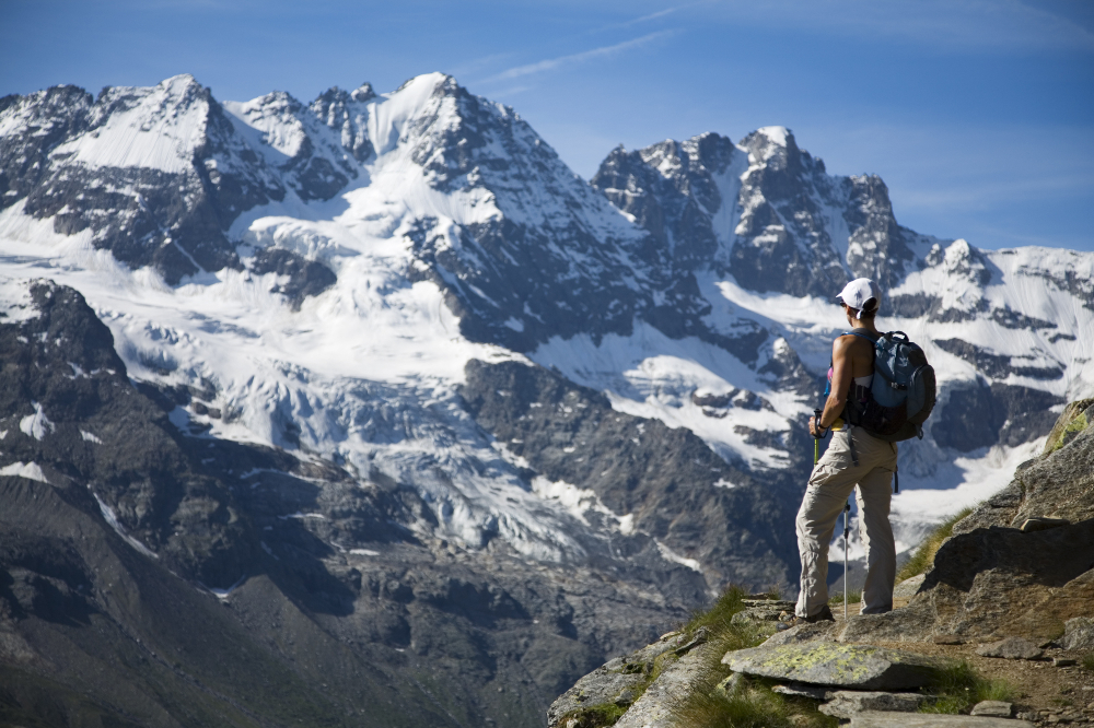
4. Alta Via della Valmalenco, Lombardy
Pros
- Not nearly as busy as other hiking destinations in Italy
- Served by a fantastically friendly and convenient hut network
- Stunning scenery includes close-up views of Pizzo Bernina, Piz Badile, the Scerscen and Palu glaciers
- A playground for ibex, chamois and wild mountain goats
- Takes in gorgeous alpine lakes, glacier views and high passes
- Local dishes pizzocheri, sciatt and bresaola are delicious!
- Easy and fun via ferrata on Torrione Porro (optional), just above Rifugio Porro-Gerli and Chiareggio.
- The Marinelli mountain hut (Rifugio Marinelli) below the Scerscen glacier
Cons
- Without a car, transportation to the trailhead from Milan is not the most convenient
- The heartbreak entailed in leaving the place!
- Very cold in winter months and routes require full mountaineering equipment
Congestion: Relatively low throughout the year
Ideal Time of Year to Hike: Mid-June to early October (huts open towards the end of June and close mid-September)
Total Distance and Duration: 68 miles, 7-9 days
Trail Uses: Hiking, running, via ferrata (optional)
Dogs Allowed: Yes.
Recommended Gear: Day pack, hiking boots, hat, water purification tablets, sleeping bag liner for huts, ice axe (Piolet style) , via ferrata kit (optional).
Elevation at Trailhead: Torre di Santa Maria, 795m/2,608ft
Max Elevation: 2,983m/9,787ft.
Total Height Gain: Around 6, 500m/21,325ft.
Costs: Around $45 per night for mountain huts (bed and breakfast) and none if wild camping or staying in unmanned mountain huts (bivacci).
Directions: From Milan, follow the directions for Lecco. From Lecco, take the SS36 in the direction of Sondrio/Bormio before joining the SS38 at Colico. Leave the SS38 in Sondrio and, on Via dello Stadio, take the left (first exit) at the roundabout and follow the road towards Torre di Santa Maria/Chiareggio/Lanzada. At Lanzada, turn left on the roundabout and follow the road until you see the red waymarking signs. At the far end of the town you’ll find the trailhead, where free parking is available.
5. Santa Catarina Valfurva
Pros
- Multiple options to explore, from day treks to cycles to multi-day mountaineering adventures
- Rifugio V Alpini in Valfurva has – no joke – a friendly fox who meets and greets visitors (and occasionally swipes their sandwiches!)
- The hot springs and spas in nearby Bormio are a great way to decompress post-trek or cycle
- Stunning views of Gran Zebru, Ortles and the Forni glacier
- Plenty of guides available for more demanding treks
Cons
- The journey from Milan is fairly long (4 hours)
- Doable in winter months, but extremely cold.
Congestion: Moderate
Ideal Time of Year to Hike: July through September.
Total Distance and Duration: Varies from day hikes to a 13-peak challenge for the more adventurous!
Trail Uses: Hiking, running, mountain biking.
Dogs Allowed? Yes.
Recommended Gear: Day pack, hiking boots, hat, water purification tablets, sleeping bag liner for huts, ice axe (Piolet style) for early in the season, crampons if venturing onto the glaciers.
Elevation at Trailhead: 1,158m/3,800ft
Max. Elevation: 3,000m/9,800ft (Passo Zebru)
Costs: $40-60 per night bed and breakfast.
Directions: From Milan, follow the directions for Lecco. From Lecco, take the SS36 in the direction of Sondrio/Bormio before joining the SS38 at Colico. Continue on the SS38 until you reach Bormio, then follow the signs for Santa Catarina Valfurva.
6. Alta Via #4
Pros
- Awesome via ferrata climbs
- The Monte Paterno ferrata (option) is highly recommended
- Great War historical remnants (hikers occasionally find bullet shells and other relics amongst the rocks), tunnels and trenches built into the mountainsides
- Passes the ‘Tre Cime di Lavaredo’, perhaps the most photographed spot in Italy after the Vatican!
- A real challenge! With some grade 2/3 climbing involved, this route isn’t to be underestimated!
- Walk, climb and scramble across the Tre Scarpèri, Croda dei Barànci, Cima Grande di Lavaredo, Cristallo, Sorapìss, and Antelao mountains
Cons
- The Tre Cime area is the busiest and most congested in all of the Dolomites
- Nigh on impossible in winter months and extremely cold
Congestion: Low to Moderate (High in Tre Cime area)
Ideal Time of Year to Hike: Late June through September
Total Distance and Duration: 53miles, 6 days
Trail Uses: Hiking, via ferrata (required).
Dogs Allowed: Varies from hut to hut.
Recommended Gear: Day pack, hiking boots, sun hat, sleeping bag liner for huts, water purification tablets, ice axe (Piolet style), via ferrata kit (required).
Elevation at Trailhead: 1174m/3851ft (San Candido).
Max Elevation: 2624m/8609m
Total Elevation Gain: 4,550m/14,927ft (a large part of which is on via ferrata!).
Costs: $35-60 per night in huts (B&B). One night free in a tiny bivouac hut…bonus!
Directions: The easiest was to reach San Candido is from Munich Airport in Germany. From Munich head South, following signs for Innsbruck, then Brenner Pass, then Cortina D’Ampezzo. From Cortina D’Ampezzo, follow signs for San Candido/Dobbiaco.
7. Alta Via of Italy #2 (Gran Paradiso Section)
Pros
- Wildlife – eagles, marmots, ibex and chamois are everywhere! If you’re lucky, you might even spot a lynx or wolf.
- Views of Gran Paradiso and Monte Bianco, two of Europe’s highest and most impressive peaks
- Passes through Gran Paradiso National Park and Mont Avic Regional Park
- Challenging total elevation gain (4,900m/16,076ft)
Cons
- Fairly busy in late July and August
- Mountain huts are quite expensive
Congestion: Moderate
Ideal Time of Year to Hike: Late June through September.
Total Distance and Duration: 87 miles, 12-14 days
Trail Uses: Hiking.
Dogs Allowed: Yes.
Recommended Gear: Day pack, hiking boots, sun hat, sleeping bag liner for huts, water purification tablets, ice axe (Piolet style).
Elevation at Trailhead: 1,223m/4,012ft
Maximum Elevation: 3,300m/10,827ft (Col Lauson)
Total Elevation Gain: 4,900m/16,076ft
Costs: $50-100 per night in mountain huts, upward of $100 in Courmayeur
Directions: From Turin Airport head south, back towards the city, then take the A5/E612 motorway north in the direction of Ivrea. Stay on the A5/E612 until reaching Courmayeur. For those using public transport, busses to Courmayeur are available from the airport.
Now…it’s decision time! Whichever destination in the ‘bel paese’ you choose, however, we’re sure you won’t regret it. For those of you with a bit more time on your hands, moreover, in all likelihood the above options list will soon become an excellent Italian-adventure bucket list.


No Comment